
Sheep Lake to Sourdough Gap and Upper Crystal Lake
I spent a crazy amount of time at Mount Rainier National Park last year. I thought driving 5 hours total to and from the park was a good idea. But to think back on it, it was definitely a good idea. I lost my job twice during the pandemic and it seemed like spending time outdoors was the best idea since there was nowhere else to go aside from staying home and powering through my UX class. In the end, I wanted to live life a little.
Getting permits during a pandemic was a lot easier than I thought. Not knowing how summer was going to turn out, I secured some permits prior to most of the park becoming accessible again. Mount Rainier never closes but the roads getting to the more popular spots do shut down for the winter season. But I didn’t end up making to about half of the permits I got including Summerland, one of the most popular spots due to it being on the Wonderland Trail and also because it’s just pretty in general. Nonetheless, since a lot of the ranger stations were still closed, a lot of the walk-in permits were made available online. I would do research for the trails where permits were still available and then register for them. I was able to grab permits for Upper Palisades and Upper Crystal Lakes. I wouldn’t say both are extremely popular compared to the rest of the park, but you’re most likely to run into a few hikers as well.
Fast forward to September - I’ve already gone on a couple backpacking trips with this girl I met online through a hiking group. It almost felt like online dating but add the pandemic to that, it definitely felt weird at first. It was a time where worrying about the other person isn’t going to care about the coronavirus was a little stressful. But this chick turned out to be amazing and we’ve become friends ever since. Plus, it never hurts to meet more people to go on backpacking adventures with. As much as I am trying to challenge myself to do more solo trips, it’s almost always more fun to go out there with company.
We were both researching what hikes we could potentially do that wouldn’t be too difficult for our level. We’re both slowish hikers and we didn’t want to hike more than 6 miles a day based on our abilities. Despite a summer being filled with hikes and adventures, we wanted to go easy on our lakes. I also attempted Upper Crystal Lake back in June but solo backpacking wasn’t a huge thing for me, so I ended up abandoning the hike and turned around. I’m weak sauce. But I needed to listen to my body. Note to self - don’t try to attempt a backpacking trip when you’re running on zero sleep because you couldn’t sleep the night before due to being extremely jet lagged. We looked at few resources and settled on starting the hike at the Chinook Pass Trailhead. I believe this trailhead also intersects with the Pacific Crest Trail (PCT). If not, you are definitely hiking on part of the PCT as you make your way back into Mount Rainier National Park.
The itinerary was simple as hell - drive to Chinook Pass, park the car there and start hiking to Upper Crystal Lake via Sheep Lake and Sourdough Gap. This is different from starting at the actual trailhead near the Sunrise entrance of Mount Rainier. I believe that road was still closed (coming from Enumclaw and past Greenwater due to the wildfires).
I submitted the itinerary online and the next day, I got the permits in the bag.
Quick Rundown: Getting Permits
This year is different from last year. Last year was also different from the prior year. I recommend checking the Mount Rainier National Park page on Recreation.gov as a lot of it has changed. And the fact that the wilderness permits are made available on that website is also a huge change. This map provided by the official NPS page also gives you a good general idea of what hikes and camps are available for backcountry camping. Please don’t take this map with you on the trail as it tells you absolutely nothing about the terrain and elevation gain and whatnot. In short, it doesn’t provide any real information. The map is solely for planning purposes.
I’m also old school so I do like to look at books and read trail descriptions everywhere to know the hike is going to meet my abilities. In addition, I also like to know what to expect on the hike. There are definitely times that I want the trip to be more like a walk in the woods - I want views.
Permits last year were easy to obtain for the most part. The regular window to get priority access to permits started on March 15 and I believe ended sometime in April. I was able to secure some popular spots. You’ll also be competing with everyone and their moms for camps that are along the Wonderland Trail. I wasn’t really looking at the WT too much so I opted for less-known camps like Palisades Lakes. I did 2 overnight trips at Mount Rainier in total but definitely wish I did more so hopefully I score permits for this year. All I did was religiously check the NPS website for Rainier - all the available camps are uploaded to a spreadsheet. I pick and choose the ones I want, fill out a simple form, and pay the park via a third-party website. This year, that would be completely different. Easy enough, it was time to pack for the trip.
Getting to the Trailhead
We did this hike in September. It was almost the end of the season depending on snow fall. But last year was an exceptionally dry year for the most part. I remember most of the Pacific Northwest were quite literally in flames - stretching from California to Washington. The weather itself wasn’t too bad except for it being exceptionally warm but the air quality was definitely terrible. Nonetheless, the skies were extremely clear when we ventured out to the trailhead. Highway 410 stretching from Enumclaw all the way into the Sunrise section of the park was still closed. But that didn’t affect the drive too much. I forgot what happened but instead of taking the main road into the park, I ended up having to take Skater Creek Road (USFS) through Packwood and eventually made my way into Mount Rainier. The road itself wasn’t fun especially when you are driving towards the sun. I blame it on the wet surfaces which made the road almost reflective and I definitely felt blinded by the sun as I was driving on a road rattled with potholes. My car pretty much ate shit when I drove into two massive potholes. Nonetheless, I carried on and eventually made my way into the Chinook Pass area of the park. I really had to use the bathroom, so I parked 500 feet from the actual parking lot my permit was listed for and where I was going to meet my friend.
When I came out from the bathroom, I realized my car wouldn’t start. After a few attempts, the car finally started back up again. I was able to make the short drive to the actual lot. I turned off the engine and yup, that’s when I realized there was something wrong with my car. The good news is there were quite a few people already at the parking lot because it was beautiful sunny day at Mount Rainier. For a while, I couldn’t figure out what happened to my car. I did realized that it might have been due to the massive potholes my car went over on the way here. I was hesitant to proceed to the backpacking trip, especially not doing what was wrong with my car. I also didn’t want to abandon the idea of spending a night in the backcountry since this was very much going to be one of the last trips I would do for the season.
A nice gentleman was finally able to diagnose the problem after many futile attempts by my friend and I. One of the cables that connected my battery came loose. He had some tools in his car and helped me fix the battery. It definitely became okay to drive but I ended up taking it to the dealership to make sure nothing else was wrong with the car after I completed the hike.
After a pretty eventful morning with my heart still beating like it was about to fall out of my chest, my friend and I finally gathered our packs and ventured out onto the trail, not fully aware of what awaits out in the wilderness.
Hiking to Sheep Lake and Sourdough Gap
The trail to Sheep Lake was easy and gentle. I think Gaia on my phone tracked about 450 to 500 feet of elevation gain. It was also an extremely sunny day with almost clear blue skies. This section definitely felt extremely exposed or should I say about 90% of this trail was exposed. There were a few social paths just before you get to Sheep Lake but they all eventually take you down to the lake. I did have the map opened up on my phone to make sure I was indeed heading the right directions. Since there were a ton of social paths, make sure you are still hiking on a trail. Plants and soil can be extremely fragile. To successfully practice leave no principles, please watch where you are setting foot.

Sheep Lake was gorgeous - I saw a few groups of people hanging around the lake. I wouldn’t call it extremely crowded compared to other sections of the lake like Tipsoo Lake. There was ample space to not really be in close proximity as the other folks. We had a few snacks here and soaked in the views. We also knew after the easy walk to Sheep Lake, we were going to start climbing over Sourdough Gap. I highly recommend stopping by Sheep Lake before making this climb on a relatively hot day. While the trail wasn’t steep or technical, when it was hot and exposed, the climb could seem a little more difficult than normal.
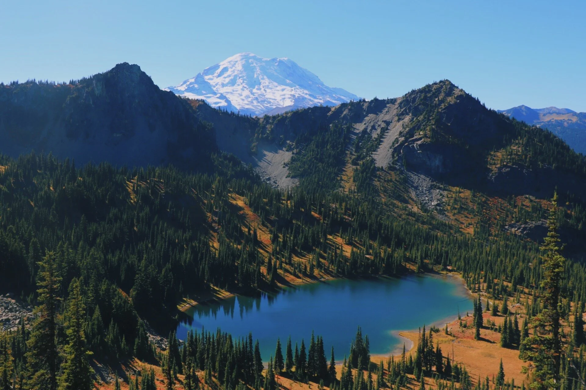
There is a little viewpoint once you climb over Sourdough Gap. Once you get there, soak in the views of Sheep Lake, it seems so small and tiny and very far away). You’ll also be greeted by Mount Adams that’s quietly sitting behind a few smaller peaks in the distance. Shortly after the viewpoint, you enter Mount Rainier National Park. Unfortunately, if you have a dog with you, you might have to turn around here since no dogs are allowed on national park lands. Mount Adams was apparently only a teaser view. A little less than a mile on the Crystal Lakes Trail, Mount Rainer has entered the chat. I recommend stopping here and enjoy the view of Upper Crystal Lake tugged below Mount Rainier. I personally think this is one of the most quintessential views of Mount Rainier (also known as Tahoma). The trail here could get narrow but there is a little path that takes you to a makeshift viewpoint if you’re down to take a break. We knew we were going to hit this spot again on the way back so we didn’t spend too much time here. We were eager to get to camp so we hiked on.
Descending into Upper Crystal Lake
Shortly after the spectacular view, you start the descend into Upper Crystal Lake. The trail is somewhat well-maintained but I could see it getting muddy after a day of rain. The descend is about 0.5 miles and you lose about 600 feet of elevation. Once you get close enough to the lake, signs for the campsites start to appear. If you’re not camping, allow yourself to just soak in the views. The lake itself is big so I could see this being a great spot for swimming and whatnot. Something about these lakes that are surrounded by the peaks that really gets to me. While this isn’t Colchuck or Blanca, you are definitely enjoying more solitude here.


At this point, my GPS had me at about 4.45 miles - there is a pit toilet near camp but it could seem a bit far from the actual trail. My friend decided to just call it a day after a morning of shenanigans with my car. It took us a while but we finally were able to find the bear poles. One good thing about backpacking in Mount Rainier is you don’t need to carry a bear can or anything like that. Most backcountry camps have their own form of storing your food. At Upper Crystal Lake, there were bear poles. Make sure you have stuff sacks that you could store your food and any scented items. The bear pole is past the main campsites and almost alongside the lake. I wish I pinpointed the bear poles on my GPS so I could find it more easily next time. But it wasn’t something that was on my mind at that time.
Since we opted for a backpacking trip on a weekday in September, we didn’t encounter a lot of people on the trail and we saw only one other person that camped there for the night. The campsites were also fully open so we definitely had options. I believe there are 3 campsites. There is quite a lot of space between each site and I want to say a good amount of privacy as well. We saw one other girl that came later in the day but between her site and ours, we couldn’t hear her and see her.
A little after 6pm - after we set up our tents, we decided to make dinner. I pulled out my JetBoil and decided it was a great idea to finally taste the Pad Thai with Chicken from Backpackers’ Pantry. I’ve read reviews of the Pad Thai and heard it was fantastic and so I was extremely excited to finally try it out. And as you may already know, I can’t go out into the backcountry without some White Claws. Sometimes I wish I could carry a few more with me but I decided that bringing 3 was good enough since I wasn’t trying to break my back while hiking. When everything seemed to be perfect out in the backcountry with the lake closely behind us, my JetBoil went up in flames. The flames got so big that it eventually melted the bottom part of my ‘stove’. This was also an especially sensitive time for wildfires. My heart once again also beat out of my chest. I quickly dumped all the water out of my bladder to extinguish the fire. It worked. I made sure everything was drenched. In my head, I was ready to throw the entire JetBoil into the lake. This wasn’t going to be an ‘easy’ backpacking trip for me - first my car then my JetBoil. Good thing I decided to bring company with me on this trip, if not I would have had to go to bed hungry. Nonetheless, the Pad Thai with Chicken was fantastic, so fantastic that it is now on the top of my list for store-bought dehydrated backpacking food. I would 11/10 recommend it to everyone. They even have a vegetarian version so vegetarians wouldn’t be missing out.


A little after 8pm, my friend and I were both exhausted. We sat around and enjoyed the sun setting behind the trees and peaks and went to bed. I wish I slept with the rainfly off but part of me gets terrified staring out into the darkness and also worried that it might rain but it clearly didn’t rain. Ever since that trip, I finally started sleeping without the rainfly off. Baby steps are worth celebrating.
Hiking back to the Chinook Pass Trailhead
The hike back was extremely easy and since we started hiking back pretty early, we had ample time heading back towards the viewpoint we briefly stopped at the day before. Fall colors were also starting to appear on the trail. This side of the mountains was not known to have larches. Nonetheless, the changing colors of the trees and leaves were still equally amazing. We took our time hiking back to the car while soaking in the views of Rainer and Sheep Lake one more time. All in all, it was an amazing trip and bonus points for not running into many people on the trail either.


Despite it being a more eventful hike than I wanted it to be, I still enjoyed the time backpacking to Crystal Lakes. I wish I had more time to explore Crystal Peaks but I feel like there is always going to be next time. I really only started doing more backpacking last summer so I feel like I am still learning a lot in regards to which trails to do and what my hiking pace is. One thing that remains important to me is that do whatever is right for your body. I think a good amount of challenging yourself is good but if it doesn’t feel right, don’t push yourself too hard. This hike was perfect for my friend and I’s level but we are definitely looking forward to doing more strenuous hikes this summer.
I also knew Chinook Pass generally closes for the season and I have yet to drive past it in the direction that takes me to Yakima. Since my friend lives in Spokane, we decided to stop by Yakima for some bomb-ass tacos. This was definitely a good conclusion to an amazing ‘weekend’ spent outside.
Stats from Gaia:
Distance: 8.54 miles (roundtrip)
Elevation Gain: 1753 feet
Total Time: 6 hours 4 minutes (took lots of time taking photos)
Pass: No pass needed to park at the trailhead, it’s technically the Wenatchee National Forest but I would have your America and Beautiful Pass handy on your dashboard or hung up just in case. Don’t forget to get a permit through Recreation.gov
Best Season: Whenever Chinook Pass opens again until whenever it closes (could vary)
Resources:
Sheep Lake to Sourdough Gap on Washington Trail Associations (WTA)
Leave No Trace Principles
Wilderness Permits on Mount Rainer NPS
Recreation.Gov - Changes to the 2021 Wilderness Permits
Happy hiking 🥾