
Lake Ann (Mount Baker Highway)

Over the past few years, I found myself consistently returning to the Mount Baker Wilderness area. I first learned about this place when my dad sent the family a photo of Picture Lake. Little did I know that this was going to be my playground one summer after another.
There are many reasons to love this area but the most obvious one is all the trails located in this area are dog friendly. When I got Tex back in 2021, the nearby North Cascades National Park sort of became off limits for me since I won’t be able to take him on the trails with me but exploring the park by water is definitely an option for those with pets.
I’ve done a couple of other trails in this area including the popular Chain Lakes Loop and Ptarmigan Ridge. Both trails offer tremendous views of Mount Baker, wildflowers in the summer, and lakes you can dive into for cooling off in the summertime!
Distance:
9.32 miles
Elevation Gain:
1923 feet
Area:
Mount Baker Wilderness
Pass:
America the Beautiful
NW Forest Pass
Overview
The Mount Baker Wilderness was created by the Washington State Wilderness Act in 1984. It spans 117,900 acres and features the active volcano Mount Baker. This area offers more than 50 miles of trails and borders the North Cascades National Park to the east and the Canadian border to the north, with the Mount Baker National Recreation Area encompassing its southern slope that includes a few other accessible and beautiful trails.
Lake Ann is nestled in the Mount Baker Wilderness. Surrounded by rugged peaks and lush alpine meadows, this hike provides stunning views of Mount Shuksan. Accessible via a moderate 8-9 mile hike, the trail to Lake Ann features diverse landscapes, including dense forests, vibrant wildflowers, and crystal-clear streams.
This trail is also used by climbers who are looking to climb Mount Shuksan via the Fisher’s Chimney route.


Overlooking Mt. Baker Highway from just below Artist Point in August 2023.
Getting to the Trailhead
Coordinates: 48.850469952688144, -121.68621039367328
The good thing about hiking near Artist Point is the road is accessible to all types of vehicles. Compared to a lot of the forest roads I’ve been to access other trails, this one is truly smooth like butter since it is paved all the way until you get to the parking lot for the Lake Ann trailhead.
The road takes you through several small towns including Acme, Deming and Glacier. I personally always find myself stopping at the Glacier Public Service Center to get up to date information about trail conditions and pick up blue bags (if I forgot to pack wag bags).
Why are blue bags important?
The Mount Baker Wilderness requires you to pack it in, and pack it out and that includes if you need to do a number 2 out in the wilderness. You won’t be able to just dig a hole and bury your waste.

Lake Ann Trailhead
There is no toilet or privy at the Lake Ann trailhead. I suggest stopping by the Heather Meadows Cafe or the Austin Pass Picnic Area to take care of business before driving up to the parking area for Lake Ann.
The parking area is not huge and gets filled up quick on the weekends or any nice summer day in Seattle. I would suggest going early but I feel like I always get luckier if I actually show up to the trailhead later in the day. That’s usually when the early day hikers and overnight backpackers complete their trip. I snatched one of the few last spots at around 3pm on a sunny Friday afternoon.
The Lake Ann parking area is not close to the Artist Point parking area so I wouldn’t suggest parking at that one. When you’re done with the hike, you wouldn’t exactly want to hike that road back up to your car. Plan accordingly, there are multiple trails to do in this area so don’t feel like you have to knock this one out if you can’t find parking.
Enough with the stats, show me the hike!

The Hike
The Lake Ann trail is a u-shaped trail in terms of how you gain and lose elevation. Initially, you lose about 800 feet in the first 2 miles. Towards the end of the trail, about 1.4 miles from Lake Ann, you will gain about 1000 feet. While the stats of the hike didn’t sound too difficult, having an overnight pack on definitely made the last 1.4 miles felt more difficult than it was. But I assure you, the views along this trail and at the end are definitely worth it!
There is a sign after hiking about 0.2 miles with some important information about the trail and a registration booth. While no permits are needed for this trail, I always like to register myself as a hiker/backpacker because 1) the rangers would at least know if something were to happen to me and my dog, and 2) it helps them keep track of how many people are using the trail.
Remember, the trail could potentially travel into the North Cascades National Park boundaries if you are planning to climb Mount Shuksan and that does require a climbing permit.
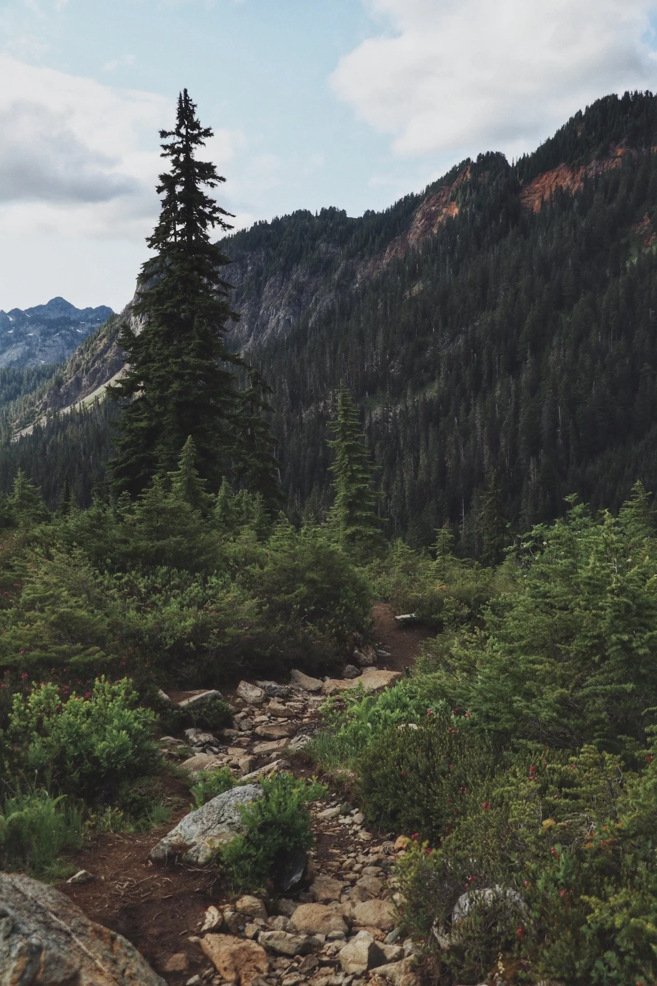
The first 2 miles

After the initial elevation loss, you are greeted by alpine meadows and will be hiking along a stream with a view of Mount Shuksan.
The first 2 miles of the hike were all downhill.
The trail was mostly well-maintained but there are lose rocks and roots here and there so I would definitely be mindful of where you are stepping. I was quite excited to get out of the forest and was amazed by how the trail really opened up. I think this was one of the most enjoyable parts of the trail. While this part of the trail was exposed, it didn’t felt too hot. My dog was also able to drink water and dip his paws in the stream whenever he needed to. Parts of this section was muddy due to the fact that the trail was at times right beside the stream. I did almost slip a couple times but trekking poles helped sturdy my steps.

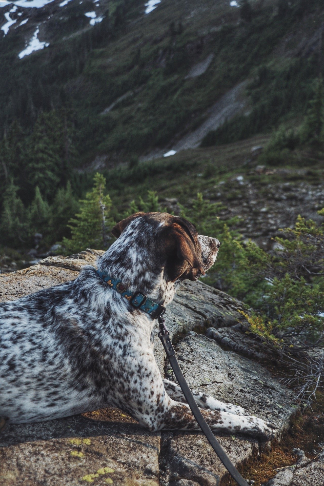
Tex was excited to be out of the forest too.

There were plenty of water sources along the hike (July, 2024)
The push before the final push
I’m not sure how to name this section because this was when you start gaining a little bit of elevation. Right after you hike to the junction with Swift Creek, you begin to gain elevation. I didn’t know this was the same Swift Creek that led to the the Baker Lake area but I saw it on my Gaia map and had a little bit of an aha moment. Perhaps, this could be a trail that I check out next time. The Swift Creek trail is also part of the Pacific Northwest Trail (PNT) which I am not super familiar with but if that’s something you would like to explore, you definitely should!
I didn’t take a whole lot of photos here because for some reason, this section felt extremely hot even though I did get a little bit of cloud coverage and hiked in the forest for a little bit. But it felt humid and muggy. By the time I started seeing more blue skies, I was happy once we left the forest and the trail opened up again.

Slowly gaining some elevation into the upper alpine meadows.
Getting above the treeline!
The last 1.4 miles
Alright, hear me out. When I mentioned earlier that I felt like this trail was moderately challenging aka more difficult than it felt like on paper, I wasn’t even sure why. I spent the weekend prior for a summit attempt of Mount Baker. My pack definitely weighed more and I was definitely gaining more elevation each step I took. But perhaps because I was already exhausted from hiking about 2.8 miles at this point and the weather felt more humid than normal.
I didn’t feel bad stopping for breaks in this section though because the views were really starting to show up. I could see Mount Baker once again. It felt so weird that just 7 days ago, I was almost on top of it.

The trail opening up as you begin to climb the last 1.4 miles to Lake Ann.

The views were starting to become unreal as I continued up the climb towards camp.
The views during the last section of the hike were so amazing, it makes you want to take breaks even though you don’t have to. But for me, I took plenty of breaks just soaking in the views and letting my dog sip on water that was trickling down the rocks on the side of the trails. When I got to this point, I was reminded why I enjoyed the Mount Baker Wilderness area so much. It always makes me smile whenever I see Mount Baker popping in and out of the clouds. It also reminded me of the first time I ever did my solo backpacking trip and was in awe of all the beauty - I did my first solo overnight trip in the nearby Chain Lakes Loop trail.
Camping at Lake Ann
I was a little worried about whether or not I would be able to find a campsite. I was hopeful when I was at the ranger station but also got a little bit nervous because the hike in took a little longer than I expected. By the time I got to the lake, it was already 6pm. However, the good thing about camping in the Mount Baker Wilderness is area is that there are generally a lot of already established campsites - ones that were clearly used as campsites before. I also met a couple that had already set up camped and asked them if they saw any campsites further down the lake and they reassured me that there are still spots available.
I trekked on and went to the end of the lake. There is a stream running down to the valley. If I crossed the lake and went uphill a little more, I was told there would be more secluded sites. However, I walked back and forth for a little while and decided to settle on a site that had semi-good tree coverage and close to the stream. More importantly, it was close to a cluster of boulders with a fantastic view of Lake Ann and Mount Shuksan.

Enough tree coverage from the elements in case the winds picked up.
Tex hanging out on a boulder overlooking Lake Ann.

Lake Ann was still partially snow covered when I did this hike in July of 2024.
I could see this area easily getting filled up by people. But I think the snow deterred some folks to do an overnight trip here. Once the snow melts, there will perhaps will more campsites available. However, if you do arrive and are unable to find a site near the lake, I was told by the ranger at the Glacier Public Service Center that there might be some more as you head on the climbers’ route towards Fisher’s Chimney towards Mount Shuksan. Do be mindful to not enter the North Cascades National Park boundaries because they have different regulations there with permits and dogs.
Dinner and Sunset
I was pretty tired and hungry when I got to camp. I pitched my tent quickly and sat on the boulder with Tex and waited for the sun to start setting. Unfortunately, there were some clouds hanging low near Shuksan, so it was slightly obstructed for the rest of the night. However, I didn’t realize how massive Shuksan truly was until I was so up close to it. It felt unreal to be sitting so close to it while enjoying dinner. I felt like life was complete.
I decided to venture out on this backpacking trip because I felt like I haven’t had time to myself in a while. In past summers, I would normally go backpacking at least 4 to 5 times. But this trip to Lake Ann was only my second one. I truly enjoy spending time in the backcountry. I prefer it more than day hikes because I get to comfortably watch sunrise or sunset without having to worry to hike back in the dark. All I had to do was to crawl into my tent and go to bed.


These trips tend to become a photo op for my dog.

I was so tired, I watched the rest of sunset inside my comfy tent.
For the rest of the night, I hung out by the lake and watched as the sun slowly set behind the mountains. There was a little bit of alpenglow action going on but the clouds were also beginning to roll in. I took a few more shots and sat on the boulders with Tex and eventually turned in early to get some needed rest.
Mount Shuksan having a glow up during sunset.
Post-Hike Noms

I got the two taco combo at Gunners - it comes with a choice of two sides, I picked the onion rings and the elote! The meats I got for my tacos are brisket and carne asada.
The hike out felt even more tiring than the hike in. When the ranger warned me that gaining the elevation back in the last mile would be hard, he wasn’t kidding. I was running out of stamina and juice and was so ready to get back to my car already. Not to mention, when I hiked out, it was a Saturday and so there were significantly more people on the trail.
After returning to my car, I stopped by the Heather Meadows to pick up their homemade Blueberry Lemonade. The lemonade always slaps after hiking and I recommend that you stop by the cafe to either grab a bite or the lemonade! I wanted to eat something more substantial without breaking the bank, so I decided to drive towards the town of Glacier to find food.
Every time I complete a hike in the Mount Baker Wilderness area, I always enjoy stopping by North Fork Brewery for a post-hike bite and drink. They have wifi and amazing pizza and brews too! For this time, I did stop by a new spot in Glacier for a post-hike lunch. I was doing a quick Google search and wanted to try something different so I opted for a restaurant called Gunners Tex Mex BBQ and I was pleasantly surprised with their food. Their menu offers BBQ and Tex Mex food that includes tacos and elote. I highly recommend checking them out if you’re heading that direction next time!
Resources
🌲 Wilderness Regulations - USFS resource on wilderness regulations
🌲 Mount Baker Wilderness - check trail conditions and fire restrictions
🌲 Chain Lakes Loop - another trail in the Mount Baker Wilderness area