
What to see and where to hike in the Columbia Gorge National Scenic Area
It doesn’t get any better than this view - standing atop Rowena Crest Viewpoint
Over the past few years, I’ve been lucky enough to spend some time in the Columbia River Gorge National Scenic Area. It’s considered a little far for a day trip from Seattle so I always have to be somewhat intentional with what spots to visit. The first couple of times I visited, the aftermath of the Eagle Creek Fire still posed potential hazards in the area. However, I returned to the area in 2024 and was able to visit some of the places that were previously closed.
There’s a lot to cover in this blog spot because there is simply too much to see in this area. I will try to cover the highlights and must-see hikes and waterfalls - this being one of the main attractions along the Columbia River.
I suggest really taking your time doing the drive as there are many spots to stop along the way and sometimes in order to really experience the beauty of this area, it’s best to actually carve out ample time to complete some of the hikes. Also, please note the scenic area is huge and I’ve only covered a small portion of things that you can do if you’re taking a spontaneous drive like I am. There are clearly lots of reasons to go back though!
Stops along the Columbia River Gorge
Start here:
White River Falls State Park
Columbia Hills State Park
Rowena Crest Viewpoint +
Hikes & Waterfalls:
Horsetail Falls
Multnomah Falls
Dry Creek Falls
Wahchella Falls
Dog Mountain +
Mosier Plateau Trail +
Lyle Cherry Orchard Trail +
Beacon Rock Trail
+ great for wildflowers!
Most of the stops mentioned in this post are conveniently located along I-84 or you are required to cross the bridge. It hugs the Columbia River but if you have time, I definitely recommend eventually getting onto the Historical Columbia Highway - more on that later. The entire highway has pretty good cell coverage so I think in this situation, it is okay to rely on Google Maps to do the navigation work for you.
Let’s start with White River Falls State Park because compared to all other locations mentioned, this one is a little ways out and I was only able to visit it because I was driving back from Smith Rock State Park. I don’t think this is technically in the scenic area but I personally think it’s worth the visit.
White River Falls State Park

Much of the drive between Bend and the Dalles was like this - this is pretty typical for Central Oregon
Season:
March 15 - October 31
Dogs Allowed:
Yes, on leash.
Camping:
Day Use Only
Website:
Oregon State Parks
I was actually really sick when I did this drive but I couldn’t pass up the opportunity to explore places I haven’t yet visited. I followed Google Maps for directions since it gave me 3 options to drive back to Seattle. I’ve done 2 out of 3 of them and figured I’d give I-84 a try especially when I realized it would finally hit some of the scenic viewpoints I’ve wanted to see. A lot of scenery along this drive reminded me of the trip I did in Eastern Oregon. Obviously, it should also remind you that yes, we are indeed in the dry part of the state, much like Eastern Washington as well. The type of vegetation was definitely different from the regular forests and tall trees you see on the western areas. Nonetheless, I still enjoyed driving it because of how far I could see on each side of the highway. I made a quick stop along the highway to see if there are potentially any waterfalls I could stop by since I didn’t have time to stop by Tumalo Falls while I was in Bend.
I found out about White River Falls State Park. The park itself is small and it is day use only. It also provided as a good rest stop for my dog and I to take a short walk down to a plunging waterfall since it must have recently rained quite a bit in the area. There is a trail that takes to you lower to the canyon to get a different view of the waterfall. I felt a little lazy and since the trail was steep and I had my dog, I didn’t do it. However, this tiny state park is a great stop if you need to get out of your car for a minute.


Columbia Hills State Park

Season:
Open Year Round
Dogs Allowed:
Yes, on leash.
Camping:
Day Use Only
Website:
Washington State Parks
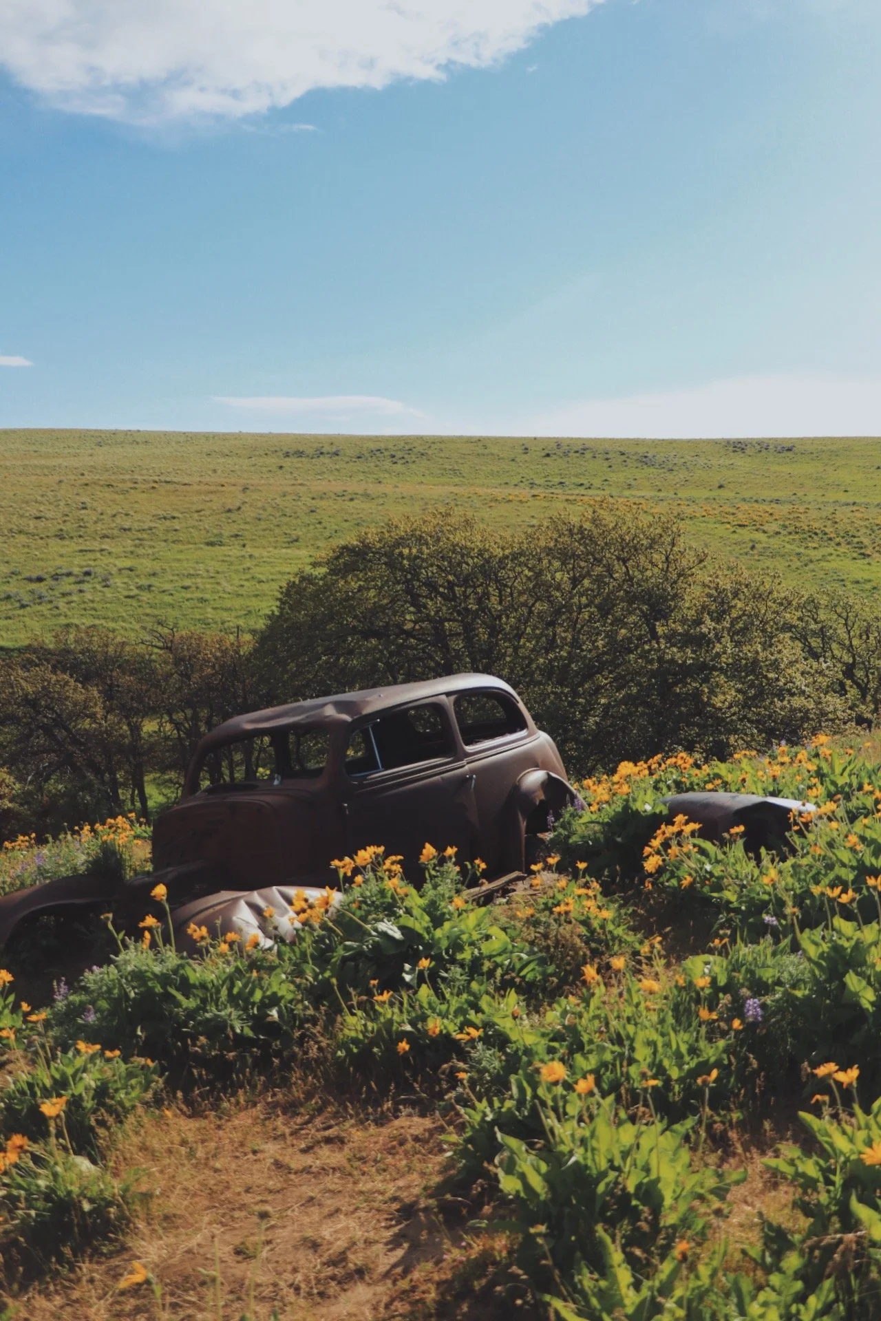
It is definitely worth visiting the Columbia Hills State Park especially during wildflower season. I think when we went in May 2022, it was already almost the end of the bloom. Nonetheless, my friend really wanted to hunt down for that abandoned car (in the second photo above) so we could take photos of her dog Milly and my dog Tex.
This park is located on the Washington side of the Columbia River Gorge National Scenic area and it does get very windy. This side of the scenic area looks a lot more different than the Oregon side. From ancient petroglyphs and rolling grasslands to dramatic basalt cliffs and wildflower-covered hills, this region offers breathtaking landscapes and rich history. Join me as I explore its hidden trails, climb to panoramic viewpoints, and capture the essence of this often-overlooked side of the Gorge.


Rowena Crest Viewpoint

Rowena Crest Viewpoint is perfect for the classic view of the Columbia River Gorge
Season:
Open Year Round
Dogs Allowed:
No.
Camping:
Day Use Only
Website:
Oregon State Parks
I’ve seen the iconic photo of the Columbia River Gorge on social media a lot but never was able to really find the spot to take the shot of the winding road. I imagine people probably got to places where they were not supposed to get that shot. However, there is much to explore in this area. Rowena Crest Viewpoint is situated along the Historic Columbia River Highway and serves at the trailhead to the Tom McCaw Nature Preserve. Due to the nature of the preserve, dogs are not allowed on any of the trails in this area. Your furry friend is allowed to enjoy the viewpoint with you though as long as they are on leash and remains in the parking lot.
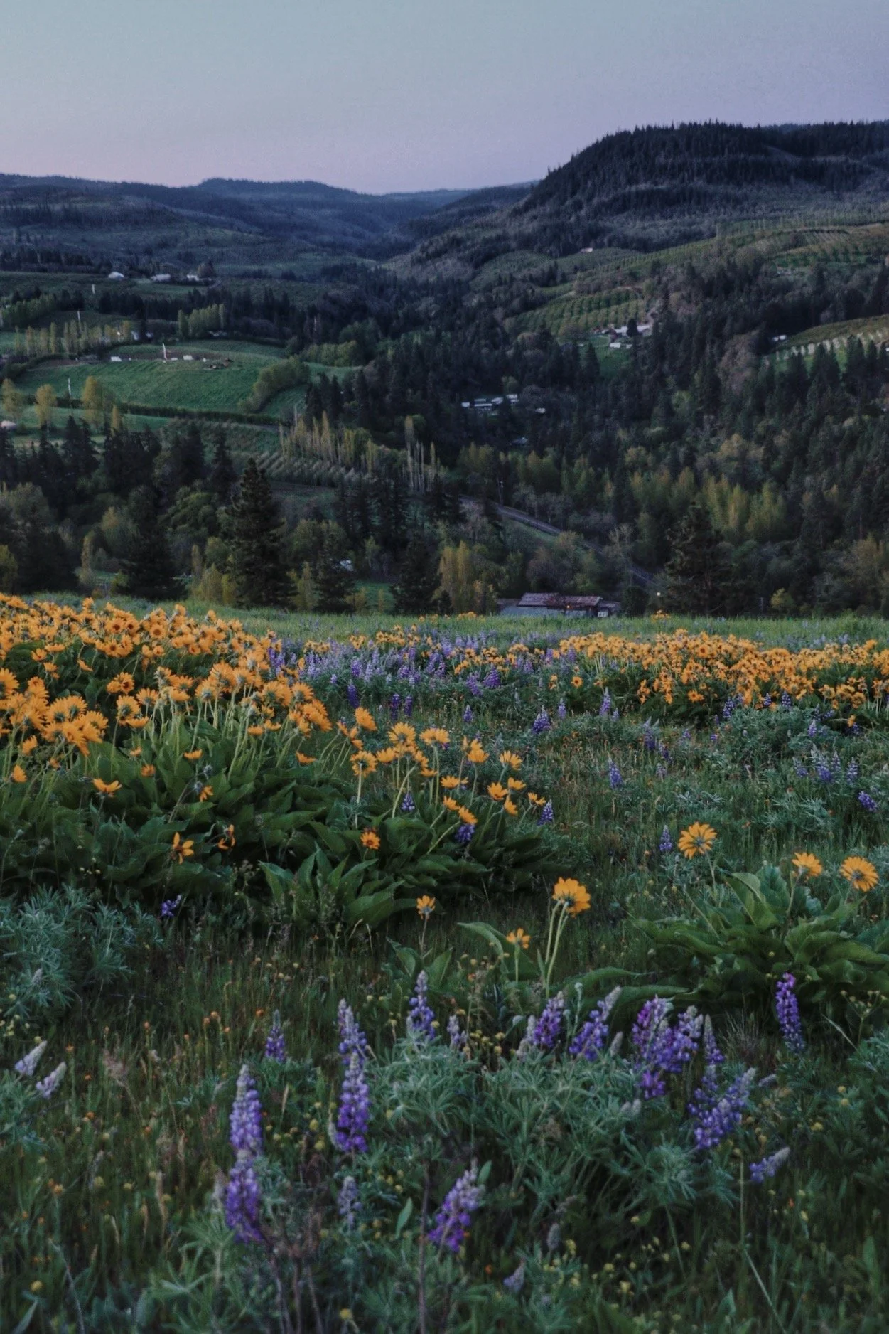
I’ve never actually completed this hike due to Tex. But I have ventured out maybe 0.5 to 1 mile into the trail. This hike is great if you are on a time crunch and only have time to visit one spot along the Columbia River. This trail is also spectacular for wildflower season which generally begins in late April or early May. For more information, this website provides bloom status and gives you good information on where to look for them.

It was very fun to drive on the Historic Columbia River Highway.

A sneak peek of when wildflowers are in bloom.
Hikes & Waterfalls
One of the highlights of the Columbia River Gorge National Scenic Area is the amount of waterfalls along the highway. There are plenty of trails that will take you up close to the waterfalls but don’t feel like you have to do all of them in one trip. Like I mentioned, there is honestly so much to do around this area that it is going to take a while to see everything. For a comprehensive list of waterfalls, I suggest visiting the Friends of the Columbia Gorge website - you can even filter by difficulty or elevation gain. Some trails will even allow you to see more than one and you can do them as a long day hike.
I didn’t visit all the waterfalls in one visit. I’ve visited this area for about four times now and still haven’t been able to see all of them mainly due to the pandemic and the Eagle Creek Fire. I am slowly checking things off my list though!
Horsetail Falls
I think this is the only other waterfall you could see roadside along the road. I did park my car in the small lot across and crossed the street to take a closer look at the waterfall. When I got there, there was barely anyone around so I was able to stand really close and get unobstructed shots of the waterfall. Although not massive, it was still cool to be able to stand so close to a waterfall - it definitely reminded of the hike I did at Silver Falls State Park, although this one was not as dramatic.
There are couple of trails that would take you to two additional waterfalls - Ponytail Falls and Triple Falls. I only had time to see Horsetail Falls, which was conveniently located next to the parking lot.


Multnomah Falls
This is possibly the most popular waterfall in the Columbia River Gorge National Scenic Area. Due to its popularity, a Timed Use Permit is required between 9am to 6pm and I believe that is year-round. The last time I visited was in April of 2024 and I didn’t realize that these permits were required. However, there is a staff member that was ensuring everyone to have their permits ready. If you don’t, they will quite literally make you get one on the spot. The Reservation.Gov website made it sound like they are made available at least 2 weeks in advance for the primary window and 2 days in advance when permits are made available for the second time. For more information, I would visit the website.
There is a hike that you could do and I believe also brings to the upper viewpoint. I was on a time crunch and since I didn’t want to take Tex to a crowded viewpoint, I opted to stay low at the lower viewpoint. There is also the Multnomah Lodge where they sell gifts and ice cream - perfect when visiting on a hot summer day!
Dry Creek Falls

Length: 4.4 miles roundtrip
Elevation Gain: 700 feet
Pass: NW Forest Pass
Dogs Allowed: Yes, on leash
Trailhead: Bridge of the Gods (Google Maps)
Dry Creek Falls has been on my list for a while but I never had the chance to visit. Since I was already in the area and wanted to find a hike that my dog and I could do together, we decided to get on this 4.4 mile roundtrip hike with about 700 feet of elevation gain to see Dry Creek Falls. The trail was easy for me and took me less 2 hours to complete. You are mostly hiking in an old-growth forest. The last section to the falls climbs gently until you reach the end and there it is, the waterfall.
The trailhead was a little tricky to find at first but there is actually a small parking area. When I did this hike, there was also a trail running event going on so the area was extra packed and made it difficult to find parking.
Wahchella Falls

Length: 2.4 miles roundtrip
Elevation Gain: 300 feet
Pass: NW Forest Pass
Dogs Allowed: Yes, on leash
Trailhead: Wahchella Falls (Google Maps)
I’ve seen this waterfall pop up on my Instagram feed many times and again, I finally had the chance to visit it. I think a lot of these places were still closed due to the Eagle Creek Fire but they have since reopened. Since this area has been impacted by the fire, I suggest really watching your step at times.
This hike was extremely popular on a sunny and warm April afternoon but it was worth it. Once you get to the waterfall, there were plenty of spots to rest and have a snack or two.
I thought this hike was a little more difficult than Dry Creek Falls since you are gaining 300 feet of elevation gain in less miles. Sections of this trail definitely felt a little steep and there were also sections that seemed to have eroded. If you are hiking with kids, keep an eye out on the trail.
Dog Mountain


Length:
6 miles roundtrip
Elevation Gain:
2800 feet
Pass:
NW Forest Pass
Dogs Allowed?
Yes, on leash.
Trailhead: Dog Mountain Trailhead
The Dog Mountain hike is quite a challenging hike but it provides exceptional views of the Columbia River Gorge. This trail is known for its wildflowers which normally starts blooming in late April. I think I went a little too early. There were some flowers starting to bloom but the hills weren’t entirely covered. I categorize this hike as challenging due to the elevation gain in a short distance. There were actually two options to hike up to Dog Mountain. One is labeled as easier and the other labeled as more challenging. We opted for the ‘easier’ option and it still kicked our butts. The last mile of this hike offers no shade so it can get extremely hot. However, once you get to the top of Dog Mountain, enjoy that cool breeze and the expansive views of the Columbia River Gorge. Have a snack, take a breather, you’ve made it!
*Please note that a permit is needed to hike Dog Mountain beginning in late April through Memorial Day Weekend on weekends only in addition to the NW Forest Pass.
Mosier Plateau Trail

The Mosier Plateau Trail offers extensive views of the Columbia River without as much effort as Dog Mountain.
Length:
2.9 miles roundtrip
Elevation Gain:
725 feet
Pass:
None
Dogs Allowed?
Yes, on leash.
The Mosier Plateau Trail is easily one of my favorite hikes in the area. It is located in the town of Mosier and parking can definitely get a little tricky. I’ve been lucky enough to find parking in a small lot just across the trailhead. However, there was a time when I had to park near the trail tracks a little further down. The latter did have more parking available but would add a little bit of mileage to your overall hike.
The first time I came here I didn’t really know what to expect. I followed the crowds of people on the narrow trail and headed up to the viewpoint. Although the trail doesn’t climb as much as Dog Mountain, it is a tiny bit of a workout. But the length of this hike is short and once you get up to the plateau, there is plenty to explore. The lupines and balsamroot were really blooming both times I was up here. I thought it was a good idea to get on this hike for sunrise and it did not disappoint. My friend and I found a secluded spot up a slope a little past the plateau and watched sunrise. It was amazing. The sun slowly rose above the horizon while slowly illuminated the wildflowers. It was quite a scene.
We visited in late April so it was definitely very chilly in the morning. But once the sun came out, we were able to warm up. However, if you are planning to do this in April, be prepared to bundle up.


Lyle Cherry Orchard Trail


Length:
6.5 miles roundtrip
Elevation Gain:
1,050 feet
Pass:
None
Dogs Allowed?
Yes, on leash.
This hike is almost like a choose your own adventure. We only did part of it and it doesn’t seem to end. I think it was because we went earlier in the season. While the balsamroot was starting to bloom, none of the ponderosa pine trees were blooming. However, it was still an interesting hike to do. More details of this trail can be found on Washington Trails Association (WTA), which gives you a comprehensive description on what to look out for on this hike.
Beacon Rock Trail


Length:
3 miles roundtrip
Elevation Gain:
574 feet
Pass:
Discover Pass
Dogs Allowed?
Yes, on leash.
I thought the Beacon Rock Trail was super cool. The trail was built on a series of switchbacks on the side of an ancient volcano by Henry Biddle.
The Beacon Rock Trail at Beacon Rock State Park is a historic and scenic hike that ascends one of the most distinctive landmarks in the Columbia River Gorge. Standing at 848 feet, Beacon Rock is the eroded core of an ancient volcano and was named by Lewis and Clark in 1805 during their expedition to the Pacific.
The trail itself was constructed between 1915 and 1918 by Henry Biddle, who purchased the rock to preserve it and build a trail to the summit. His carefully engineered route features 52 switchbacks, bridges, and handrails, making the steep climb both safe and accessible. Today, hikers can follow this historic path to enjoy stunning panoramic views of the Columbia River, a reward well worth the 1.8-mile round-trip trek and 600 feet of elevation gain.
Conclusion
I feel like I’ve only scratched the surface of places to explore within the Columbia River Gorge National Scenic Area. There is plenty to see and do. I always wish I had more time to visit all of the places but despite visiting this area on several separate occasions, there is simply too many options. With that said, I will continue to update this list whenever I explore a new hike or state park or activity - so keep checking back! I hope this list provided you with at least a starting point of places you can go visit. Spring and summer are busy seasons for this area because of the wildflowers and the relatively moderate temperatures even in late April (although chilly mornings do exist).
Resources

Here is a list of resources that could help you plan your trip. I’ve included the state parks I camped at as well so you can stay closer to where the adventures begin.
Friends of the Gorge - provides a ton of information on hikes, history of the Gorge and conservation efforts to keep the area clean and accessible.
Recreation.gov - Dog Mountain Permits
Beacon Rock State Park - this state park has camping and a couple of hiking trails.
Columbia Hills State Park - has multiple hiking trails
Maryhill State Park - because Columbia Hills doesn’t have camping, we camped at the nearby Maryhill instead.
Multnomah Falls Time-Used Permits
Rowena Crest Viewpoint - information about Rowena Crest and the Tom McCall NatureBeacon Rock State Park Preserve