
Goat Rocks Wilderness

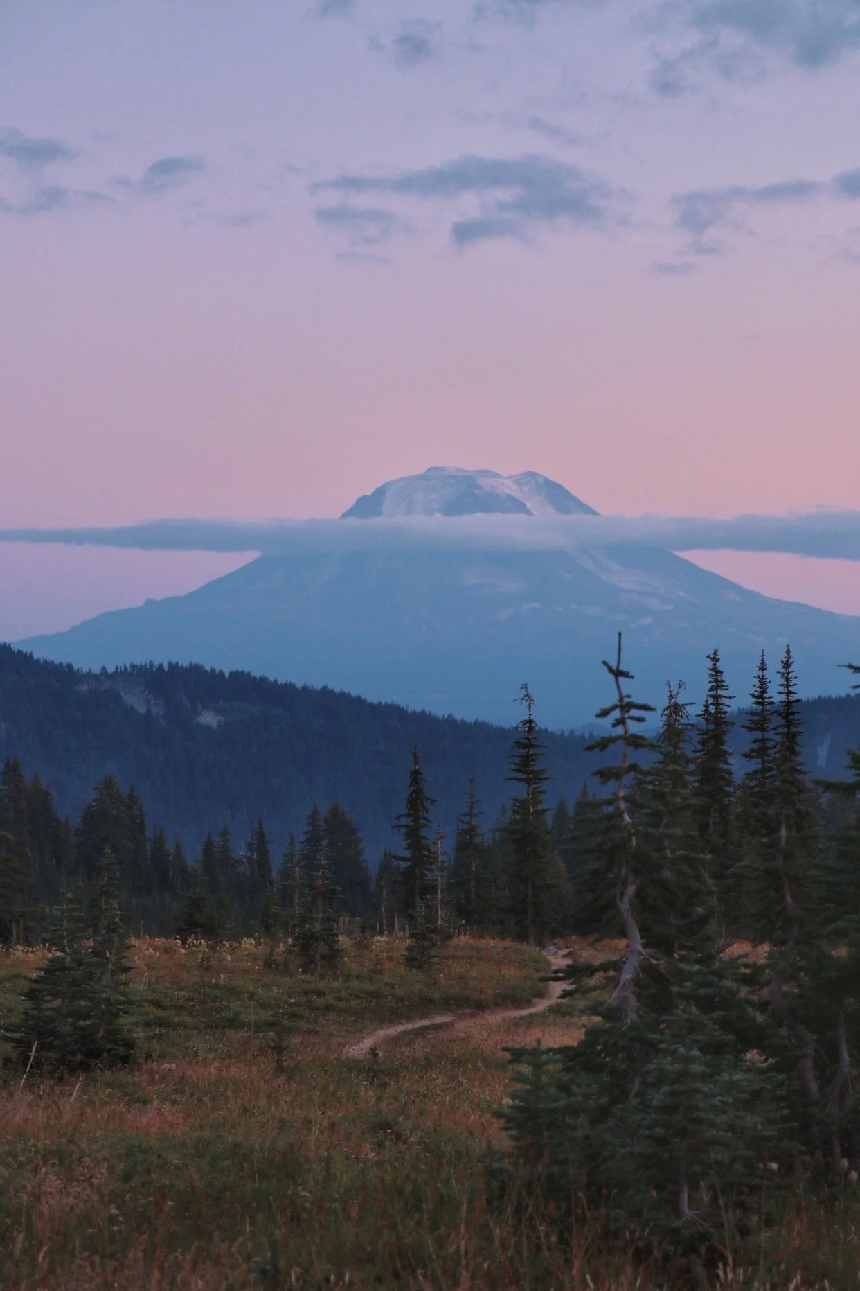
Mount Adams rising up near the PCT junction at Snowgrass Flats
Stats from Gaia GPS:
Distance:
22.7 miles
Area:
Goat Rocks Wildnerness
Elevation Gain:
4738 feet
Pass:
NW Forest Pass/America the Beautiful
I am not sure why I never got to writing a post about backpacking Goat Rocks Wilderness. I was extremely prompt when writing up the trip report for Ptarmigan Ridge which I did a few days after I completed the trip to Goat Rocks. This remains to be one of my favorite hikes I’ve done ever since I started backpacking. I haven’t done a lot of trips but this was a memorable one and it was my first time venturing out into the wilderness with a group of folks. I enjoy my fair share of solo backpacking trips but having people around at camp and provide motivation to push through the steep sections of the trail were great.
I completed this loop back in September of 2021. During that time, the area was highly affected by wildfire smoke. Even though we were ways out from where the fires were burning, I think another started up while we were completing the loop. 2021 was a bad year for the wilderness as we experience higher temperatures and drier conditions. Nonetheless, the area was still beautiful and we still lucked out on being able to see all three mountains - Mount Adams, Mount St. Helens and Mount Rainier.
We did the entire loop in 2 days - I know some people like to take their time to complete the hike because there are actually a lot of spur trails such as connecting with the PCT to head towards Knife’s Edge and heading up Old Snowy Mountain as well. We were a little tight on time and this was actually a backup plan because the Cascade Pass Trailhead was closed.
The best season to hike this trail would probably be from July to September as most of the trail is above 6000’ and snow lingers well into the summertime.
Getting to the trailhead

I left Seattle at 5:30am so that I could get to the trailhead by 9am
Some people have voiced concerns about the road to the trailhead. To get to Goat Rocks, most of it really is on a paved road. I was driving from Seattle so the drive felt familiar because I spent a lot of time taking the route through Packwood Lake towards Mount Rainier National Park. Instead of heading to the park though, the road takes you further down Packwood until you take a turn onto a forest road. It was your regular FS road and I had no problems driving in my Honda Civic. Once you get closer to the trailhead though, the road narrows significantly and this was also where the potholes started appearing. Again, it was your regular rough forest service road so I wouldn’t be concerned. It was definitely passable for all vehicle types.
The only advice I have is to drive at a reasonable speed especially when you are making a turn. As mentioned, the road is narrow and sometimes it gets difficult to see oncoming traffic. Be prepared to yield for larger vehicles if possible, especially trucks with trailers as the road also leads to the Walupt Lake Campground.
Berry Patch Trailhead: 46.46684, -121.52661
We started at the Berry Patch Trailhead, I’m not sure if it made a huge difference. We’ve done research and thought starting at the Berry Patch Trailhead would be a better idea but forgot why. It turned out the Snowgrass Flats Trailhead was only a short drive away. There were bathrooms at both trailheads but the latter seemed to fill up quicker than the former.
Day 1: Berry Patch to Snowgrass Flats
6 miles / 2125 feet of elevation gain
Once you get on the forest service road, you lose cell service so don’t expect to be able to use your phone at this point. I always carry my Garmin InReach Mini for a peace of mind. Prior to getting to the trailhead, I thought I had send a text message but it never sent. There was a little bit of confusion when I was trying to meet my friends at the trailhead. At that point, I just waited until they showed. They obviously finally did. Once they did, we all chugged a quick pre-trail beer and hit the trails.
No advanced reservations are needed for backcountry permits in the Goat Rocks Wilderness, but you do need to get a self-issued permit at the trailhead. Information needed would be your name and party size. There might be more information but my friend filled out the permit so I didn’t actually get to see it as only one person needed to fill it out.
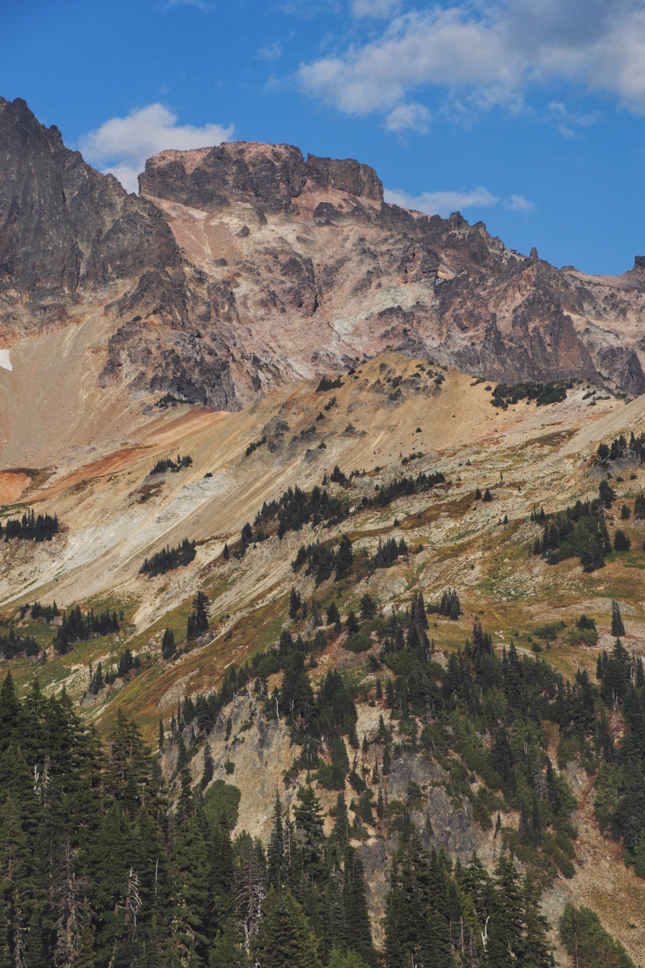
On the first day, we took it easy. Our goal was to head to the junction where Snowgrass Flats intersects with the Pacific Crest Trail (PCT). We also heard there would be a stream further down the PCT towards Cispin Pass. I believe we hiked about 6 miles that day to get to the area where we wanted to set up camp. There were plenty of small running streams to fill up on the way but it was hard to tell because the weather had been extremely hot and dry around the time we completed the hike. The first 6 miles of the trail was straightforward, the trail was well maintained and the inclines were moderate at worst. Some trip reports mentioned the first section was quite boring and our group agreed it wasn’t spectacular - it was the typical walk through the woods. It wasn’t bad but we were ready to exit the forest and get the views we were all anticipating.

Snowgrass Flats - finally waited for the moment when we existed the forest and went above treeline
We originally found a really nice patch to set up our tents but we were worried that the wind might pick up in the middle of the night and the spot we looked at was also quite exposed. We decided that we wanted more protection from the elements so we opted for an area that had several trees around. We quickly set up our tents and refueled. Although the hike wasn’t difficult for the day, we were still exhausted and desperately needed to get water to hydrate. We headed further down along the PCT, collected water and headed back to camp. If you go further along the PCT, you will eventually get to Cispin Pass. We attempted to get all the way there for sunset but we decided we would just hang out at a random spot along the trail. We were quite content with the view. We ate more snacks and I had some of the wine I brought with me before we decided that we would head back towards camp because we remembered that watching Mount Adams during sunset was a better idea.


We quickly packed up and hurried our way back to camp.
Needless to say, the sunset was one of the best ones I have seen in a while. It was always a treat to backpack to an area where all you could set your eyes on were the views that surround you. The skies began to turn into a violent series of colors before slowly darkening into a deep navy blue while Mount Adams was still able to shine through the darkness.


After witnessing quite an epic sunset (even though there was no cloud inversion of some sort), we hung out at camp for a bit before I was too tired and had to go to bed. Since we were in the middle of wildfire season, we were unable to have a fire but the temperatures were perfect especially with the Mountain Hardwear Bishop Pass 15 sleeping bag I had. The weather was also so nice that I didn’t even bother putting my rainfly on. My friends stayed up to do some astrophotography and at this point, I was already sound asleep.
Day 2.1: Snowgrass Flats to Knife’s Edge
5.14 miles / 1987 feet of elevation gain
We got up quite early as the sun rose before 6am. Our plan of the day was to hike towards Old Snowy Mountain and potentially hiking to another junction where the trail meets the PCT trail. I quickly made coffee and chowed down a granola bar before we left with our day packs to complete the ‘plan of the day’.
As we made our way towards it, we actually found some fantastic camp spots on the way. Secluded and protected. I definitely noted these down so if I ever get a chance to hike the loop again, I would probably try to camp at one of those spots as long as I know to fill up my water bladder before setting up camp because there was no water between where we camped and to Old Snowy Mountain. There was still some snow but really not a lot.

There was no rain forecasted so I ditched the rainfly and slept like a baby

The trail was filled with late season wildflowers
We did eventually make our way up to Old Snowy Mountain - it was quite underwhelming compared to the views we had gotten the night before at Snowgrass Flats. We spent a little time there exploring and eventually decided we wanted to explore part of the PCT headed towards Knife’s Edge.
The trail to Knife’s Edge was quite precariously. It was also a horse trail and to be honest, just by looking at the trail, I couldn’t imagine horses would comfortably make it but they somehow do. There were still some snow patches along the way which made the trail even more sketch. It didn’t help that the sun was also starting to rise to its highest position as noon approached. Nonetheless, we made it through the sketchiest section of the trail and I was relieved as Knife’s Edge came into view. The views were sweeping even when everything was covered in a light haze. I could still see Mount Rainier towering from a distance.
When I got to this section of this trail, my jaw literally dropped. I have done high elevation hikes before but nothing felt quite accomplishing as being to see this section in person. I munched on my beef jerky as I saw several PCT hikers flew by me. It was actually nice to see people back on the trail since a lot of the permits to hike the PCT was cancelled due to the pandemic.
On the way to Knife’s Edge, there is a tiny boot path that brings you to this magnificent view of Goat Rocks Wilderness


After soaking in the views, we decided to head back to camp and pack up as we still had a long day ahead of us.
Day 2.2: Snowgrass Flats to Goat Lake
2.32 Miles / 762 feet of elevation gain
Once we headed back to our camp, we had another important decision to make. In my head, I definitely wanted to complete the rest of the loop. We already saw so much of the Goat Rocks Wilderness but I wanted to see even more of it. I heard Goat Lake was definitely worth checking out and that was actually where most backpackers end up in. My friends were a little hesitant but eventually I was able to convince the rest of the group to take the ‘long’ way back to the Berry Patch Trailhead.
We followed along the Lily Basin Trail, the views here were definitely different from what we experienced on the first day. The first day consisted a lot of hiking through the forest. But now, we were hiking along the ridge and was able to get views all around us. Since it was a hot day, even when the elevation gain wasn’t tough, the heat was definitely tough especially because we already did about 5ish miles of hiking in the morning. I didn’t take too many pictures on this section of the hike because I was extremely exhausted and was just trying to get to the viewpoints. When we got to Goat Lake, we once again filled up our water bladders and bottles. My friend also had some electrolytes with him which definitely helped with staying hydrated.
We made it to Goat Lake! This picture doesn’t do this place justice - the water was turquoise blue and super clear
Day 2.3: Goat Lake to Berry Patch Trailhead
5.19 miles / 922 feet of elevation gain
The last section of the hike required a lot of trying to push myself to complete the hike. While the elevation gain was minuscule compared to the rest of the hike, it was the last stretch and every step felt heavier than the step before. I was actually glad that we decided to do this hike counter-clockwise. This section was steep even when we were descending most of the time. I couldn’t really imagine hiking up the steep inclines with my heavy pack on (of course I could, but would I prefer that? No, haha). The last stretch of the trail brought us back to the forest which was still beautiful but compared to the rest of the hike, it felt a little underwhelming. But I was happy to hike on flat ground as my body and feet were both screaming at me.
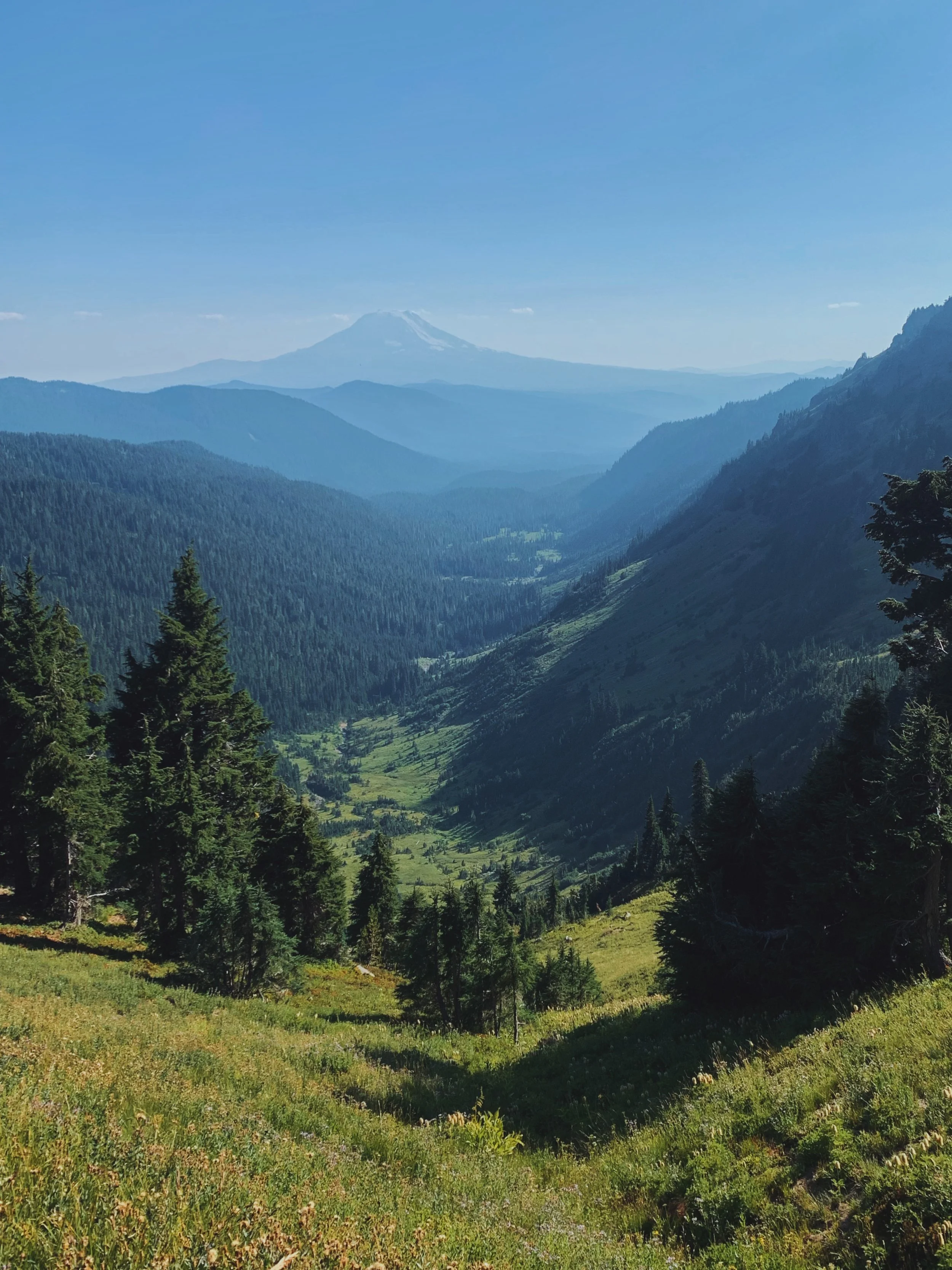
Mount Adams seem so far away as we continued on with the hike to complete the loop

So close yet so far - almost back to our car!
We Made It 🥳
When we finally got back to the parking lot, we were all ready to get out of here and grab food. We stopped by a small bar/restaurant in the Packwood area. While the food wasn’t gourmet, a cold beer felt extremely good after completing the 22-mile loop.
Hiking in the Goat Rocks Wilderness has been on my bucket list for a while. Our original plan was actually to hike to Sahale Glacier because my friend was able to somehow score permits but due to a road closure, we had to come up with a backup plan. The weather was as good as it got despite the haze from numerous wildfires burning across Washington state. I can’t wait to come back to this area and explore it again. I can’t imagine what everything would look like if the haze wasn’t there. I probably would have also picked another camping spot and potentially allow myself more days to do the hike because it definitely felt a little rush when we did the loop.
Nonetheless, it was still a fantastic time out on the trail. I also felt like this was a good challenge for myself as I slowly ease into longer distance hiking because the plan is to complete the Timberline Trail around Mount Hood this summer.

We’ve backtracked just a little bit since we needed to get back to the junction to finish the loop - we did this hike counterclockwise
Resources
USFS website - get updates on trail conditions and a general overview of what to expect on the trail
My trip report on WTA - I wrote this shortly after I completed the hike
The 7 Leave No Trace Principles - always good to brush up on this before heading out
Finding a Good Campsite from the PCT Association - helpful when it comes to areas without designated campsites