
Anderson and Watson Lakes

Watson Lakes sitting next to each other after you finally leave the forest and make the last descent into the lakes.
Situated in the beautiful Mount Baker Snoqualmie National Forest and the Noisy-Diosbud Wilderness, the Anderson and Watson Lakes trail features plenty of variety - from hiking through a lush forest to stepping over small streams to eventually finding yourself at Watson Lakes, the crown jewel of this quintessential Pacific Northwest hike.
Distance:
6 miles roundtrip
Elevation Gain:
1100 feet
Area:
Mt Baker Snoqualmie National Forest
Noisy Diosbud Wilderness
Pass:
NW Forest Pass
America the Beautiful
Overview
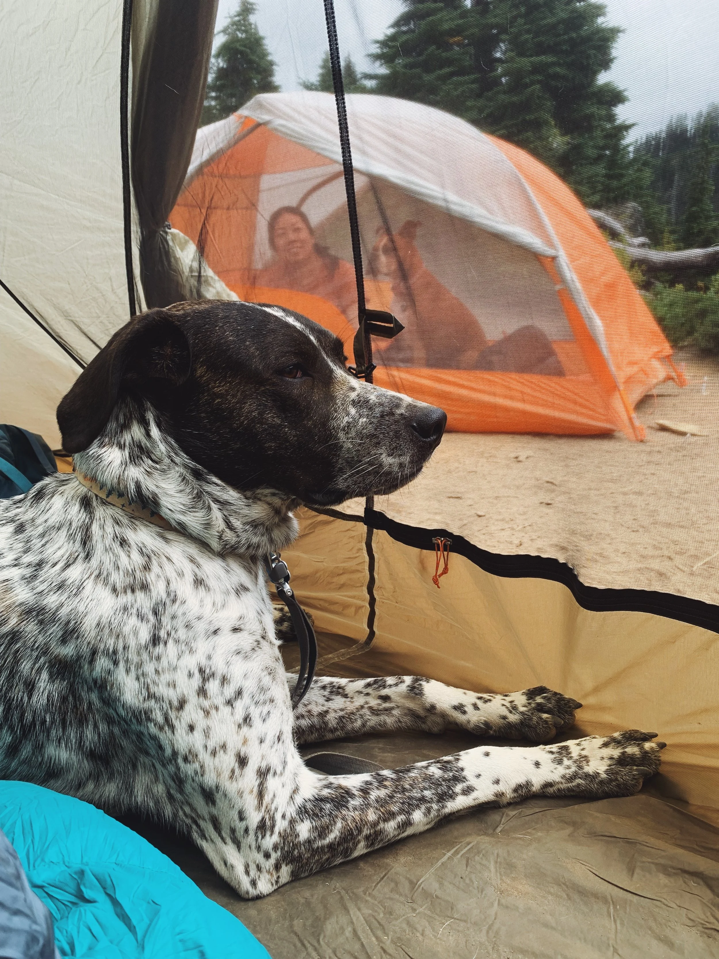
When my friend Caroline and I were trying to decided where to head to for our first backpacking trip together, we had a few ideas but eventually settled on this trail because of its moderate difficulty and we knew we were going to be treated with some views. Plus, it makes for a great last minute backpacking destination because this hike doesn’t require any permits. It’s also dog friendly, which allowed both of us to bring our four-legged companion with us.
I did this hike in August 2022. The best seasons for this hike will be late June through September.

When I did this backpacking trip back in 2020, I didn’t hike all the way up to Watson Lakes. There was a ton of wildfire smoke and haze so my friend and I opted to keep this easy just in case we needed to hike back out when conditions worsened even though there was no immediate danger in the area we hiked in, meaning there wasn’t a fire burning closeby.
So pick you adventure - if this is your first backpacking trip ever or the season, I recommend setting up camp at Anderson Lake. While the views are not as good as Watson Lakes, there is plenty of space to hang out and on a clear day, you can see Mount Baker (Koma Kulshan) as well. To make the drive up here more worthwhile, Watson Lakes is definitely a great destination. I do think campsites get filled up here quickly when the weather is nice. But don’t let that deter you, you can still find plenty of solitude if you hike further up a less established trail and around the far side of the lake - more details on this later.
Getting to the trailhead

Trailhead coordinates: 48.67473, -121.61490
Driving from Seattle, it takes about 2.5 hours and the directions through Google Maps are pretty accurate.
I picked up my friend Caroline from the Eastside at 6ish in the morning and got some breakfast along the way. We got to the trailhead at around 8 and began hiking a little before 8:30.
The road to the Anderson and Watson lakes trailhead actually goes by the Baker Lake trailhead. Continue going straight onto the National Forest Development Road 1107. It’s hard to miss the trailhead because the road opens up to a reasonably sized lot with one of the cleanest pit toilets I’ve seen.
As mentioned, I did this hike up to Anderson Lake back in 2020. Back then, it seemed like the road was rough but passable if you go slow in a low clearance vehicle. However, I can no longer comfortably recommend this road to any low clearance vehicles. After passing the parking lot for the Baker Lake trailhead, it was a series of rocks shooting out from the ground and with some of the nastiest potholes I’ve ever encountered. I drive a Honda Civic Hatchback and I’ve definitely bottomed out a few times despite doing 20mph and less and really maintaining a speed of 10mph most of the time.
Anderson Lake: 1.9 miles

My friend Caroline hiking up some stone steps as we made our way further into the trail towards Anderson Lake.

We made it to the Noisy-Diosbud Wilderness, only less than a mile before we can set up camp for the night.
When we did this hike, the forecast was overcast with pockets of sunshine here and there. It never rained but we were hiking mostly in the clouds and honestly, made for better conditions for the both of us.
The start of the hike beggan in a forest. Thanks for the Washington Trail Associations (WTA) crew parties, there were a few small wooden bridges installed to make crossing streams a lot easier. About 0.6 miles into the hike, you arrvie to your first interaction. To the left, you will find a boot path with a sign ‘Anderson Butte’. We didn’t care to hike up to the butte as we were determined to get to Watson Lakes as soon as possible to secure a good campsite.
After the intersection, the trail began to open up as you continue meander up a gentle hill which was often lined with small patches of wildflowers. The elevation gain here was gentle but could potentially feel hot when there are no clouds in sight because it was rather exposed. However, don’t forget to look back as Mount Baker sits quietly in the back as it sends you off the trail. Because of this, it definitely provided some encouragment as we continued to push towards Watson Lakes.
Another 0.62 miles after the first intersection, you will arrive at another intersection. The right path takes you down to Anderson Lake while continuing straight would bring you to Watson Lakes. Our idea was to maybe stop by Anderson Lake on the hike out.
After the second intersection, you officially enter the Noisy-Diosbud Wilderness, meaning wilderness regulations do apply here. The link takes you to a PDF file that provides a good overview of what some of these regulations might be.

Caroline was all smiles when she got a first glimpse of Watson Lakes

First sneak peak of the Watson Lakes, almost there!
Watson Lakes: 2.08 miles
Once you see the sign that reads ‘Noisy-Diosbud Wilderness’, you are only a little over a mile before reaching Watson Lakes. This was also the first time we got some views since we left Baker behind as we made our way closer to the Noisy-Diosbud Wilderness.
There was a little overlook here with a great sneak peak of what was ahead. Again, due to the overcast skies, Watson Lakes was playing peek-a-boo with us. Nonetheless, our stoke level was pretty high at this point. We took a quick break here. Even though the sun wasn’t out the entire time we were hiking, it felt really humid.
The trail narrowed significantly after reaching the overlook and became really steep at times. But this was nothing some trekking poles and sturdy shoes couldn’t solve. As we slowly made our way down the steepish trail, we were happy to finally reach the first Watson Lake. We did notice there were some campsites along the first lake. But we decided we wanted to go further to see if there was anything else that would 1) bring us even closer to the lakes and 2) potentially find a little more solitude since the campsites along the first Watson Lake seemed fairly exposed.
Getting to camp

It took us about 2 hours to get to Watson Lakes, hiking very leisurely and stopping occasionally to soak in the views.
The orange route shows our traverse around the first and second Watson Lake. On the Gaia app, it does say most of the sites are located between the two lakes which we did see on our way. There were no defined paths but it was obvious that some sections were more heavily used than others. Always try your best to hike on these types of paths to better practice leave no trace principles.
As we continued onto the second Watson Lake, we did come across a tricky part where we had to cross a larger stream. While most of the trail had boardwalks installed to help you get over the streams, this part was trickier due to having dogs and heavy backs on our back. But we quickly made our way over it and found the perfect site to pitch our tents.
I can’t tell you exactly how many camp spots we encountered along the way but we did notice a lot of spots that had seen use from previous backpackers. Again, choose wisely and only camp on durable services. Good signs to look out for are bare grounds (without any wildflowers or lots of grass) and sometimes a used fire pit could also help identify a spot (although this can vary as some wilderness areas prohibit fires altogether or when you reach a certain elevation).


After setting up camp, we had some snacks and enjoyed views of the lake. Since we both had quite an early start for a not so long trail, we were both pretty exhausted. By the time we got done with setting up our tents and ate a little, it was noon and we both decided that we were going to lay down in our tents before heading out to explore the surrounding area.
Exploring Watson Lakes
We spent a lot of time just hanging out at camp near the lake because honestly, it was one of the best campsites I’ve camped in. Nonetheless, Caroline noticed there was a little path that potentially would lead up to a nice view. After reluctantly waking up from my nap, we decided to venture out this boot path to see what was in store for us.
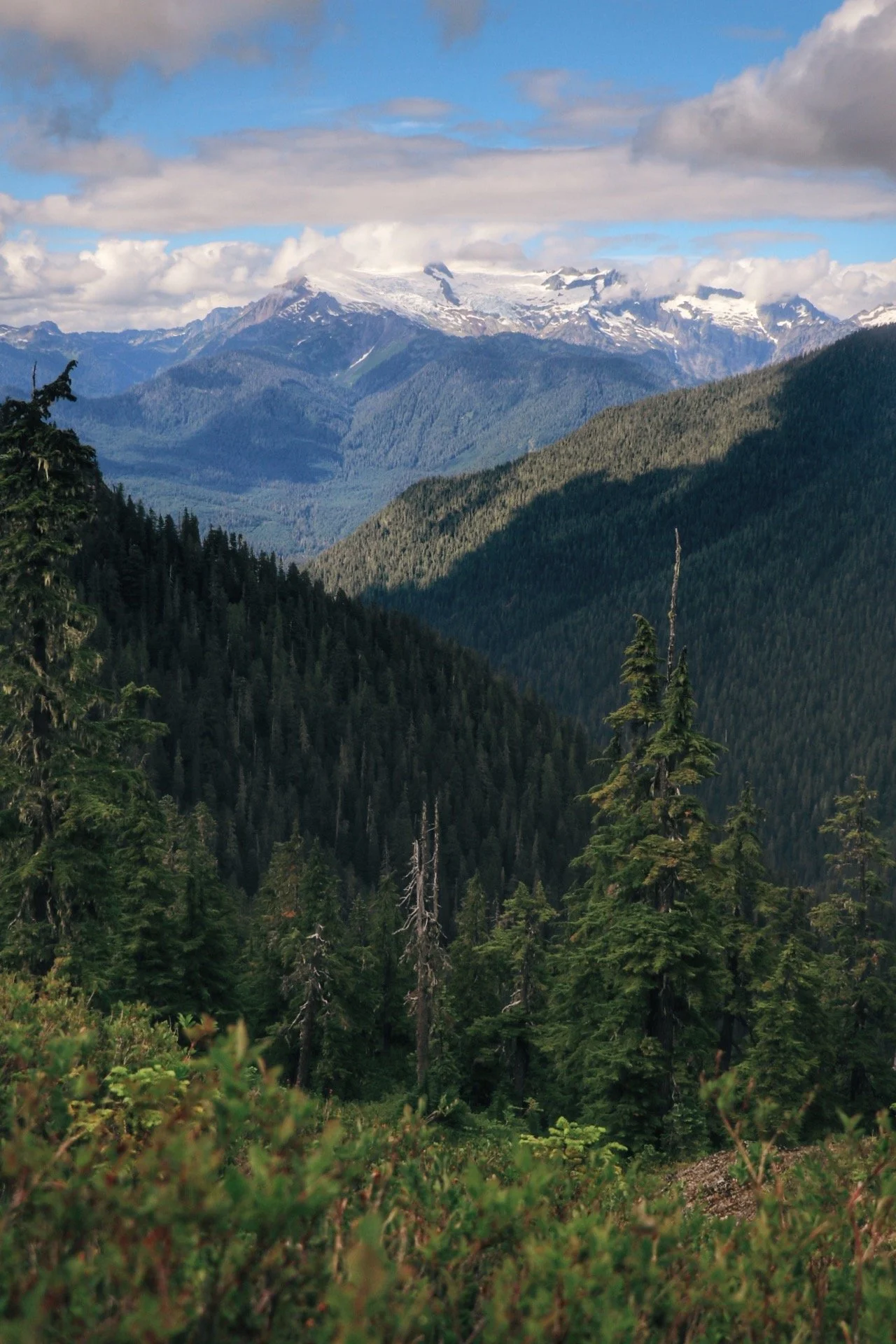


This boot path wasn’t maintained at all even though you could tell people have hiked on it. Aside from that, it was overgrown so there was a lot of bushwhacking and walking into branches. At times, it became really steep that I might as well just have sat down on the trail and trust the process. After roughly 10-15 minutes of struggle, we made it to this little ridge overlooking presumably North Cascades National Park. I noticed Mount Shuksan was in the view. While I still don’t know if the bushwhacking was worth the effort, I was content with the view.
After taking a bunch of photos with our dogs and soaking in the view one last time, we headed back the way we came from and after being whacked from branches countless times, we made it back to our campsite. We didn’t do much for the rest of the night aside from taking more photos and chatting the night away while enjoying dinner with a great view. We noticed the skies were clearing up. Caroline was especially excited because she said it was supposed to be a full moon.

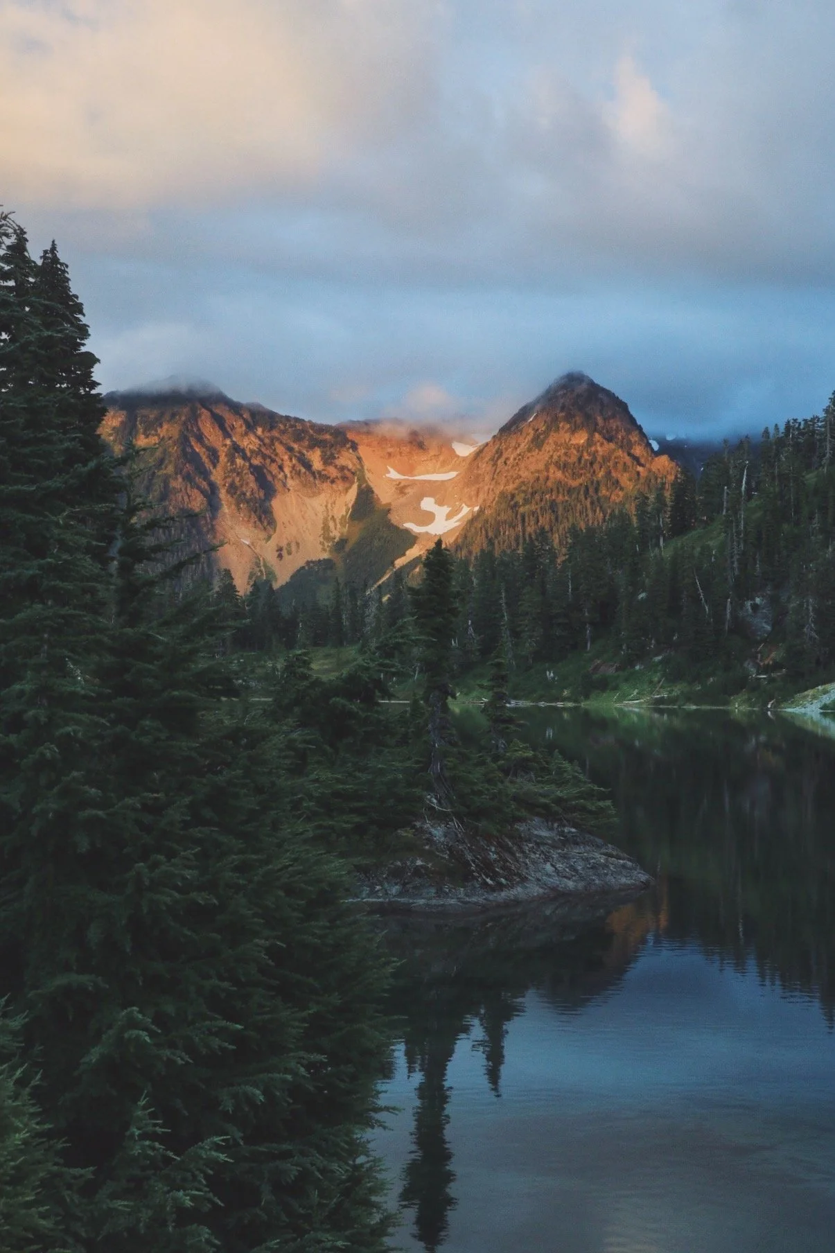
Golden hour hitting Watson Lakes.

The hike out
We woke up fairly early in the morning and were greeted by blue skies. The sky did clear up and it definitely felt significantly warmer than the day before. We spent some more time eating breakfast with winning lakefront views before we decided to pack up and head back to the car. We had plans to stop by at Anderson Lake on the way out as well.
We came back the way we came from and instead of going straight to the boardwalk, we took a left and headed down to Anderson Lake. I’ve never enjoyed this part of the hike because you lose quite a bit of elevation descending into Anderson Lake. While the trail was maintained, there were also a lot of overgrown roots sticking out. However, with a little huffing and puffing, we made it down to the lake. I snapped a few photos while Caroline reapplied insect repellent and we were on our way again.


The hike out felt significantly different because it was sunny and the fog cleared. We were able to see a lot further and the wildflowers definitely looked a lot different in sunshine. Remember I mentioned earlier that don’t forget to look back as Mount Baker sits quietly behind you as you hike towards Anderson and Watson Lakes? This was the spot.
I was pretty over it once we left the exposed section of the trail and back into the forest. So I hiked a little faster than normal and waited for Caroline to emerge from the forest at the end of the trail.

Final Thoughts
This was a moderate backpacking trip for me. While there wasn’t a lot of elevation gain on this hike, it definitely felt a little difficult at times with descending and ascending on rougher terrain. Nonetheless, I had a great time backpacking with my friend Caroline and our two dogs, Milly and Tex. I recommend this backpacking trip to anyone that:
🥾 Can’t secure a permit at one of the more popular areas
🐶 Have dogs - a lot of the more popular trails don’t allow dogs (think The Enchantments and National Parks)
⛰️ Easy to moderate hike to two alpine lakes with views of Mount Baker (Koma Kulshan)
That’s all I have for this photo essay slash trail report. I hope you enjoy this trail as much as I did and hope to see some of you on the trails this summer as well.
Resources:
🌲 Wilderness Regulations - USFS resource on wilderness regulations
🌲 Official USFS page of the Anderson-Watson Lakes trail - check to see current conditions
🌲 My trip report on WTA - I wrote this shortly after I completed the hike
🌲 The 7 Leave No Trace Principles - always good to brush up on this before heading out
🌲 Finding a Good Campsite from the PCT Association - helpful when it comes to areas without designated campsites